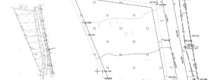
Topographic survey of the site
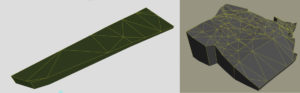
Based on the data provided by the customer (video, photo of the site and topographic survey), we analyze your plot of land. Based on the topographic survey, we make a 3D model of your piece of land with all the slopes and heights. This helps us to accurately fit the building on your real piece of land. We describe in more detail about topographic survey and why it is needed below.
We need a topographic survey in order to correctly place the building relative to the boundaries of the site. Understand where the site has entry and exit. Perhaps there are trees, rocks or structures on the site, which we must take into account when designing.
Based on the topographic survey, we make a 3D model of your site. If required and there is a slope on the site. We design taking into account the peculiarities of the site. Plots of land may be different. For some they are of the correct shape without a slope, and for someone they are with a large slope. We take all this into account in our work and design it on your real piece of land.
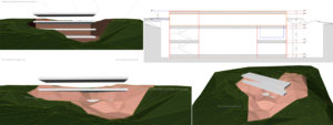
We send visual materials to the customer. An example of planting a house on a piece of land that has a strong slope.